Google Maps Chiswick’s Streets
|
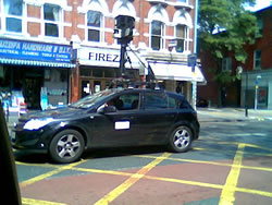
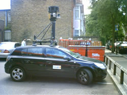
Google’s man on the ground was out and about in Chiswick this week taking a series of street level images which will be made available to the rest of the world via the internet.
Google Streetmap is a new feature of Google Maps which will provide an eye level view of streets as opposed to the bird’s eye view currently available.
Chiswick resident Alice Shimmin explains, “It allows a user of Google maps to get a street level view of a location.
"You can actually see what the buildings look like. They do this by driving a car round all the roads taking pictures as it goes.”
She continued, “From these photos it's clear that they are now doing this in Chiswick.
"The driver of the car said he was mapping South West London.”
July 31, 2008