South Chiswick To Be Transformed By Range of Traffic Measures
Access restrictions on Thames Road, Havard Hill, Hartington Road and Staveley Road
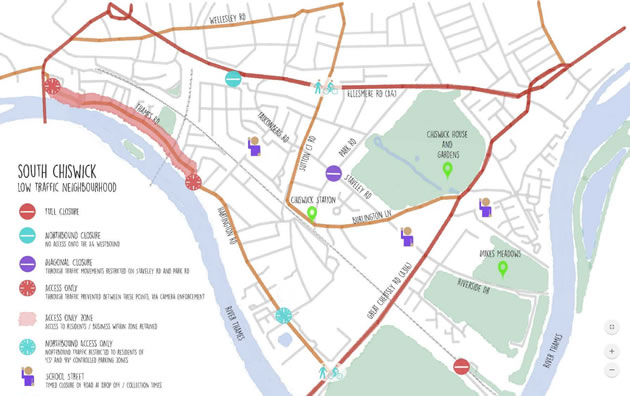
Map of the proposed changes. Click here for larger version
|
A raft of measures are being introduced by Hounslow Council in South Chiswick with the intent of reducing traffic in the neighbourhood. They are the result of the South Chiswick Liveable Neighbourhood project in which residents were asked to contribute their ideas about improving the neighbourhood by changes in the way traffic is managed.
The measures that are to be introduced include making Thames Road access only controlled by automatic number plate recognition cameras (ANPR), restricting access to the A4 from Havard Hill, introducing a range of school streets which will restrict vehicle access to local schools during drop off and pick up times, a ‘diagonal road closure’ at the Staveley Road/Park Road junction. Northbound traffic on Hartington Road is to be restricted to residents only.
The council say that, in response to the government’s policy of encouraging local authorities to implement schemes that assist pedestrians and cyclists ‘as swiftly as possible’, they are accelerating work on existing projects which provide these benefits, including the South Chiswick Liveable Neighbourhood project. This project combines a range of schemes across the Grove Park and Dukes Meadows area that focus on increasing the number of trips made by foot, bike and public transport while aiming to improve local public space.
The details of the measures are as follows:
• Strand on The Green / Thames Road: An access only zone to prevent through traffic. The zone is proposed to stretch from the Kew Bridge / Strand on The Green junction, to the junction of Grove Park Terrace / Grove Park Road. Vehicles would be allowed to enter the zone to access residential properties and businesses in the area unchanged, but not to pass through both points as part of a longer journey. This would be monitored by automatic number plate recognition cameras (ANPR) at both entry and exit points to the zone, to enforce against any traffic trying to make a through movement. The feasibility and design work for this scheme is ongoing, details of which will be provided to residents prior to the trial commencing.
• Harvard Hill: The closure of the road northbound, to prevent access onto the A4 westbound. Turning off the A4 into Harvard Hill will remain in place.
• Grove Park Primary: A ‘school street’ scheme, designed to restrict vehicle access at school drop off and collection times. These schemes introduce timed closure of roads around schools, to reduce access to schools by car. Resident access to properties will be maintained at all times. This scheme would include Nightingale Close and a section of Grove Park Terrace. The extent of the closure is being considered and will be communicated to residents as part of the experimental traffic order process.
• Hartington Road / Cavendish Road: The introduction of a northbound ‘access only’ restriction, to remove non-residential through traffic. Northbound access to drivers will be open to residents only, via a permitting system. Pre-registered licence plates would be able to continue to travel in a northbound direction. It is proposed that this will be open to residential properties in the ‘CS’ and ‘RV’ controlled parking zones. Non-registered vehicles from outside the zone would therefore have to find an alternative route via the A316. Southbound travel along Hartington Road, and through the zone, would remain unchanged. The details of this proposal will now be developed and shared with residents prior to any trial commencing.
• Chiswick School: A ‘school street’ scheme, designed to restrict vehicle access at school drop off and collection times. This scheme would include a section of Staveley Road between the A316 and Burlington Lane. The exact extent of the closure is being considered and will be communicated to residents as part of the experimental traffic order process. Existing bus access is proposed to remain unchanged.
• Staveley Road: A new diagonal road closure at the Staveley Road junction with Park Road. This measure will prevent traffic heading east/west along Staveley Road and north/south along Park Road. It will still be possible for vehicles to turn left from Staveley Road into Park Road, when travelling in both directions. However, any vehicle wishing to continue straight ahead will need to find an alternative route. The junction will remain open for cyclists in all directions.
• Cavendish Primary School: A ‘school street’ scheme, designed to restrict vehicle access at school drop off and collection times. This scheme focuses on a section of Edensor Road, between the A316 and Edensor Gardens. The exact extent of the closure is being considered and will be communicated to residents as part of the experimental traffic order process. Existing bus access is proposed to remain unchanged.
Temporary measures on the Transport for London Road Network, to be requested as part of the Council’s response to Covid-19:
• Sutton Court Road / A4 junction: explore opportunities for temporary measures that benefit pedestrians and cyclists, including possible temporary traffic signals, changes to existing signal timings, temporary cycle lanes and improved pedestrian crossing points. In order to successfully deliver change at this location, it will be necessary to agree changes to traffic signals managed by Transport for London.
• A316 / Dan Mason Drive / Hartington Road junction: explore opportunities for temporary measures that benefit pedestrians and cyclists, including possible signal timing changes that allow for a dedicated pedestrian crossing phase. At present there is no green/red signal for pedestrians, which can require crossing between fast moving, turning traffic.
Dan Mason Drive has already been closed to traffic underneath railway line, and access to the South Circular (A205) had been restricted from Stile Hall Gardens and Wellesley Road.
The Council ran a public consultation in late 2019 and collected data on traffic volumes, speeds and movements across the area. They say the feedback from residents, schools, businesses and local community groups has been reviewed along with the traffic data and a series of trial measures has now been brought forward as part of the Council’s Streetspace project.
The proposals aim to transform the area into being a ‘low traffic neighbourhood’, preventing motorists from using residential streets as a cut through between major roads. They are trying to achieve this by introducing a range of closures and access restrictions, to reduce traffic speeds and volumes in the area.
Councillor Hanif Khan, Cabinet Member for Transport at Hounslow Council said, “The south Chiswick Liveable Neighbourhood project was borne of a need to address public safety and quality of life for residents in the area and predates the pandemic. We have had extensive engagement with local residents and analysed traffic data to devise a range of measures that will transform the area into a low-traffic neighbourhood. It makes perfect sense to implement these measures now before people begin to return to their place of work and children return to school, so that these measures become embedded as the ‘new normal’ and residents seize on the opportunity to switch to walking and cycling more as it will now be safer to do so.”
It is intended that the first of these proposals are introduced from the end of June, with all measures being in place by September. This is subject to funding being secured from Transport for London. All measures are proposed to be trialled for a minimum of 6 months. The project website also contains more information on the consultation results, the traffic data collected and the explains the proposed measures in more detail.
https://southchiswicklnmap.commonplace.is/
Like Reading Articles Like This? Help Us Produce More This site remains committed to providing local community news and public interest journalism. Articles such as the one above are integral to what we do. We aim to feature as much as possible on local societies, charities based in the area, fundraising efforts by residents, community-based initiatives and even helping people find missing pets. We’ve always done that and won’t be changing, in fact we’d like to do more. However, the readership that these stories generates is often below that needed to cover the cost of producing them. Our financial resources are limited and the local media environment is intensely competitive so there is a constraint on what we can do. We are therefore asking our readers to consider offering financial support to these efforts. Any money given will help support community and public interest news and the expansion of our coverage in this area. A suggested monthly payment is £8 but we would be grateful for any amount for instance if you think this site offers the equivalent value of a subscription to a daily printed newspaper you may wish to consider £20 per month. If neither of these amounts is suitable for you then contact info@neighbournet.com and we can set up an alternative. All payments are made through a secure web site. One-off donations are also appreciated. Choose The Amount You Wish To Contribute. If you do support us in this way we’d be interested to hear what kind of articles you would like to see more of on the site – send your suggestions to the editor. For businesses we offer the chance to be a corporate sponsor of community content on the site. For £30 plus VAT per month you will be the designated sponsor of at least one article a month with your logo appearing if supplied. If there is a specific community group or initiative you’d like to support we can make sure your sponsorship is featured on related content for a one off payment of £50 plus VAT. All payments are made through a secure web site. |
June 8, 2020