
MORTLAKE, BARNES AND DUKES MEADOW
Key Characteristics
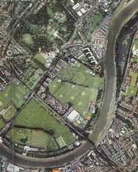
This character reach, crossed by two bridges, Chiswick Bridge (road) and Barnes Railway Bridge, is dominated by the fragmented open recreational landscape of Duke's Meadow which faces the historic riverside village of Mortlake. Chiswick House and Gardens are an important reminder of former riverside mansions, although they no longer retain their historic link with the River. To the south of the River, is Mortlake Cemetery, the imposing Stag Brewery, St. Mary's Church, and the historic riverside development of Barnes Terrace. |
 |
Key features of this character reach may be summarised as follows:
- Chiswick Bridge is an important focal and viewing point;
- St. Mary's Church, Mortlake is a local village landmark;
- Watney's Brewery continues an industrial riverside tradition;
- Historic Chiswick House and Gardens present an opportunity for improved links with the River;
- Duke's Meadow is an example of issues in evolving riverside open space;
- Barnes Railway Bridge presents an opportunity for improved cross-river links;
- The historic riverside of Barnes Terrace is undermined by the existing floodwalls.
Key Issues and Opportunities
DUKE'S MEADOW
- There is a need for an integrated approach to the management of both public and private open space at Duke's Meadow, together with the playing fields and sports facilities on the other side of the A316. At the present time there is a lack of investment in public open space and issues relating to maintenance.
- The potential future role of this extensive area of riverside open space needs to be addressed. At the present time investment and management decisions are taken on a piecemeal basis. The area has the potential to act as a Regional Park for south-west London, with the emphasis on watersports and active recreation. The renaissance of the 1920's riverside promenade would be a key element of the overall scheme. A strong landscape framework based on the historic avenues and hedgerows would provide the overall setting. The Friends of Duke's Meadow have commissioned such a plan, now in its public consultation stage.
- Any schemes for managing or re-landscaping Duke's Meadow should ensure that the tree cover is sufficient to screen the urban elements and retain the green aspect in views across the River.
The intrusive glare of floodlighting from sports facilities should be minimised by tree screening, modifications to lighting and careful control of the siting of new facilities.
- A consortium of local sports clubs, led by Hounslow Hockey Club, is proposing using Chiswick Boathouse as a super club house for all the amateur clubs on Duke's Meadow, together with two all-weather floodlit pitches and the reorganisation and improvement of existing facilities, which raises the question of the appropriateness of such "urbanised" sports activities on MOL. There will be a requirement to examine the potential impact of more intensive recreational facilities and the potential for appropriate mitigation and siting.
Duke's Meadow has an active community group "The Friends of Duke's Meadow". They have been successful in gaining support from the local community, Hounslow Council and the British Trust for Conservation Volunteers (BTCV). The following opportunities for enhancing the landscape, recreation and nature conservation value of the area have been identified:
Landscape
- The renaissance of the 1920's riverside promenade, terraces, bandstand and recreation ground at Duke's Meadow.
- Replant the gaps in the lime avenue (Promenade Approach) linking Chiswick House to the River, and restore the views of the River and the pumping station.
- Screen the large sports buildings associated with the private clubs on Duke's Meadow by tree planting and improved boundary treatment.
- Reduce the visual impact and noise of traffic on Chiswick Bridge Approach by planting, possibly in combination with earthmodelling.
- Selectively thin rows of Lombardy Poplars at Pevral Pier and other locations where they block views of the River.
- Reduce the number of fences within Duke's Meadow and improve their visual appearance.
- Introduce new tree and shrub planting along boundaries.
- Create new "gateways" at the entrances to the area. Restore the ornamental gates at the entrance to Promenade Approach.
Public Access and Recreation
- Restore the overgrown footpath along the riverside promenade at Duke's Meadow and signpost as the Thames Path National Trail. Cyclists to use Riverside Drive.
- Open up the arches under Chiswick Bridge to provide a direct connection for the Thames Path, avoiding the busy A316 Chertsey Road. Realign path to follow foot of embankment.
- Examine the feasibility of creating a tunnel through the railway embankment to the north of Duke's Hollow, to provide a direct route for the Thames Path.
- Signpost Chiswick House from the River and vice versa, using the historic avenue along Promenade Approach.
- Maximise the potential of the local authority owned Chiswick Boathouse, possibly as a focus for a wider range of watersports.
- Provide for large numbers of spectators to view the final section of the University Boat Race, which ends at Chiswick Bridge, subject to safety considerations.
- Promote new events and activities, for example the farmers' market in the pavilion area.
Nature Conservation
- Protect the integrity and ecological value of the mudflats and shingle habitats within the River channel.
- Protect and manage Duke's Hollow as a local nature reserve.
- Examine the feasibility of "rediscovering" the Bollo Brook and opening up its outlet with the Thames
- Eradicate the invasive Japanese knotweed which has colonised most of the northern riverbank between Chiswick and Hammersmith Bridges. Establish a long-term management regime for riverbank vegetation.
- Introduce a management regime for the trees along the riverside removing over time the non- native sycamore and Lombardy poplars and replace them with native alder and willow.
Extend the range of inter-tidal habitats by localised modifications (for example at under-used car parks) to the flood defences, subject to safety considerations, to create retired defences with a succession of wetland habitats.
- The potential exists to create a significant new wetland area on the north bank of the river immediately upstream of Chiswick Bridge. This would involve taking under-used space from the playing fields and creating retired flood defences.
MORTLAKE
- It is important that any future redevelopment of the brewery site should strengthen the unique character of the Mortlake riverfront and respect the setting and views of Thamesbank, St Mary's Church, the granary building, and Tapestry Court. In the event of the granary becoming available for development, an appropriate use(s) should be secured which retain the character of the building and add to the vitality of the riverside.
- There are likely to be further pressures on individual sites for redevelopment or conversion of existing buildings. The old Barnes Council Depot building was converted into "The Depot" a popular riverside brasserie, and workspaces. There is a vacant site awaiting development at 77 Mortlake High Street. Any development proposals should take into account the local context and include appropriate provision for river enhancing activities and enhancement of the riverside environment.
- The need to protect and interpret the remnants of Mortlake's industrial heritage and riverside infrastructure, including the slipway and drawdock;
- Repair and restoration of the traditional cobbled sloping revetments and the historic steps that lead to the foreshore and provide safety equipment and information on tides.
- The opportunity exists to enhance the underused Jubilee Gardens on the Mortlake riverside as a contemporary urban space.
- Encourage improvements to the visual quality of the existing Stag Brewery, and in particular the control of advertisements.
- The network of historic passages and alleys between the river and Mortlake High Street, such as Bull's Alley, are poorly defined and in need of restoration.
- In conjunction with the repair and replacement of the flood defences, sensitively surface the Thames Path National Trail between Thamesbank and Barnes Terrace, whilst retaining the remnants of its industrial heritage.
BARNES TERRACE AND RAILWAY BRIDGE
- The need to maintain the high visual quality and skylines of the architectural waterfront at Barnes Terrace.
- Introduce sensitive traffic management and street scene improvements, to reduce the heavy traffic severing Barnes Terrace from the river, and restore the public realm. Short term measures could include a pedestrian crossing opposite Barnes Bridge Station.
- Protect the view identified in the UDP from Barnes Terrace to the River and Duke's Meadow.
- Investigate opportunities for lowering and replacing the unsympathetic flood defence wall which detracts from the setting of the listed buildings along Barnes Terrace. The choice of materials and design of the wall and handrails should be sympathetic with the Terrace and include more viewing bays and appropriate tree planting. In the short term consideration could be given to raising sections of the walkway as viewing platforms.
- Selective thinning of riverside vegetation at historically designed viewpoints along Duke's Meadow to open up and frame views to landmarks within Mortlake (St Mary's Church and the granary building), and Barnes Terrace (with suitable screening behind, to protect the views from Barnes).
- Restore and improve the visual appearance of Barnes Railway Bridge, including repainting to a colour scheme agreed with the local community (and English Heritage), repair of the steps at the Duke's Meadow end and improvements to lighting.
- Examine the feasibility of reopening the upstream older section of Barnes Railway Bridge as a cycle path linking directly into Barnes Bridge Station, with ramped access down the railway embankments at both ends of the bridge.
- Improve and enhance the pedestrian and cycle link from Chiswick Station, across Duke's Meadow, using Barnes Railway Bridge. Signpost connections to the Thames Cycle Route and the Wetland Centre at Barn Elms.
- Enhancement of junction of Barnes High Street and river redevelopment of Barnes Police Station on Lonsdale Road provides the opportunity to replan this area. Consideration should be given to traffic management measures to reduce the impact of traffic in the High Street and appropriate parking controls through the provision of off-street parking. The potential for the creation of a focus of interest such as a pier could be considered.
- The need to restore the Small Profits Dock slipway and adjoining open space on Lonsdale Road.
Back to Thames Strategy Main Page