Lost In Chiswick? Not Surprising If You Follow Legible London Board
Incorrect information on street sign sending people in wrong direction
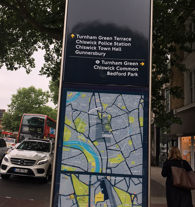
|
Finding your way around Chiswick should not be that difficult, there is a long High Road, and two main side streets containing shops and items of historical interest.
But a new information board, part of the Legible London range designed by TfL, at the junction of the High Road and Turnham Green Terrace, has left some people scratching their heads.
The board (on the pavement outside Snappy Snaps), refers to Chiswick Police Station, which closed last December, and also points people towards Turnham Green Terrace which the will have just past in the opposite direction. A resident of Ravensmede Way was alarmed to see his road had been wiped from the map and a compass points in completely the wrong direction.
Hounslow Council claim the signs were consulted on extensively in 2017 and that the mapping follows TfL’s approved processes common across London. Hounslow has now been made aware of the errors and is consulting with the sub-contractor.
The Legible London signs were approved by the Council and TfL before the police station closure was known, a spokesman said. There is a process for updating the map to reflect changes to the environment and this will be undertaken in due course.
He added that, based on other areas of the borough and in his experience, most people have welcomed the signs - particularly landmarks slightly off the beaten track such as Chiswick House which the signs help highlight.
Councillor Joanna Biddolph raised the matter with Hounslow Council and questioned what the criteria was for deciding what should be included. For example there is an arrow to Sainsbury's on one of the signs, but she says that Chiswick also has a Waitrose, and a large number of independent shops.
"The list of churches also seemed random and singling out the Packhorse & Talbot where there were many other pubs, also historically significant, and why just pubs?
"It seems very odd to impose on us more street furniture, adding to a sense of clutter, and providing information that doesn’t accurately reflect our neighbourhood. "
TfL says it developed Legible London to help both residents and visitors walk to their destination quickly and easily. Nearly every London borough has at least one of the more than 1,700 Legible London signs. There is a variety of signage, from monoliths, to traditional finger posts.
"Rather than having north at the top, on-street signage maps are 'heads-up', which means they're orientated to face the same way as the user is facing. This helps people understand their immediate environment more easily."
If anyone spots other errors, they can raise them by emailing traffic@hounslow.gov.uk.
Councillor Hanif Khan, Cabinet Member for Transport and Corporate Property said, “We have listened to the feedback from residents and to clarify, Hounslow Council led on installing this sign and Transport for London produced the mapping that accompanies it. There is a huge amount of data displayed on the sign and a number of subcontractors involved in the process of gathering and checking data, production and installation, therefore the process can be quite complex. To date around 50 legible London signs have successfully been installed in Chiswick, Hounslow and Brentford town centre.
"The council has paid for updates to the mapping system used for these signs and relatively recently announced changes such as the police station closure will be captured by that process in due course. We will look into the other issues raised and consider whether remedial works to the sign are required. With regard to which party will pay for any remedial works required, this will depend on where the source of the error lies. This may be one of the subcontractors involved or this may be the council, but we will know in due course.”
July 3, 2018